


Contract-based computation service with RIAM-COMPACT® Natural Terrain Version
We provide a simulation service for the wind condition at a proposed site for wind power generation facilities. The simulation is performed with the use of the 50m elevation data from the Geographical Survey Institute of Japan. “Wind paths” and “wind disturbances” of the target area are visualized in the form of animation, and qualitative wind characteristics are evaluated.
In addition, we convert the time series data of wind speed at the wind turbine hub-height into graphs. We also provide quantitative evaluations such as the vertical profiles of wind speed and turbulence intensity for the proposed locations of wind turbine installation.
The computation service comes with an option for high-resolution wind simulation which uses elevation data with a spatial resolution of less than 10m. As additional options, we can also estimate the annual wind energy generation (kWh) and utilized capacity (%) by taking into consideration the correlation between the simulation and field observation data.
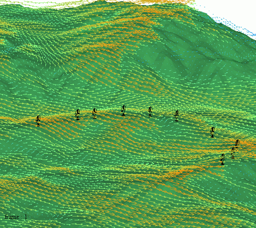
Figure 1. Wind speed vectors at the wind turbine hub-height
 Visualization Gallery
 List of data to be offered
- Map of the area targeted for computation
- Computational parameters
(e.g. details of inflow wind conditions such as wind speed and wind profile) - Animation of wind velocity vectors at the wind turbine hub-height (see Figure 1)
- Animation of wind disturbances at the wind turbine hub-height
- Time series graphs of wind speed data from the wind turbine hub-height
- Vertical profiles of mean wind speed at the proposed locations of wind turbine installation (see Figure 2)
- Vertical profiles of turbulence intensity at the proposed locations of wind turbine installation
We provide the above data summarized in PowerPoint.
Time required
- Approximately 10 days for one wind direction (general guideline)
Options
- High-resolution simulation by including elevation data with resolution finer than the 50m elevation data of the Geographical Survey Institute of Japan. Elevation data with resolutions of 10m or less are constructed from topography maps of 1:2500 or from CAD data in DXF format.
- Estimates of the annual energy generation (kWh) and utilized capacity (%) (see Figure 3). These estimates are made using the results from the wind simulations individually performed for 16 wind directions.
(Please note: the estimate of the annual energy generation requires field data (bi-hourly time series data) observed in at least one location for a year.)
Fee for contract-based computation
- Please contact us for estimates
(e.g. 200,000 yen and up for contract-based computation using 50m elevation data from the Geographical Survey Institute of Japan).
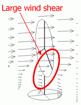 |
Figure 2. Velocity vectors in the vicinity of a wind turbine (the blow up and blow down angles with respect to the wind turbine can be estimated.) |
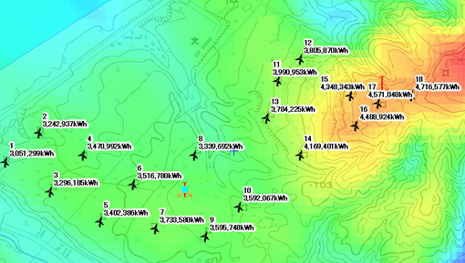 Figure 3. An example of a constructed wind synopsis map with an estimate of the annual energy generation (kWh) |
|