


Intended mainly for sites within Japan
Detailed 3D topography data creation service for use in RIAM-COMPACT® Natural Terrain Version
Creation of topography from paper maps of approx. 1:2500 and CAD data in DXF format
At low cost and with a short delivery time, we will create detailed 3D elevation data from sources such as paper maps of approximately 1:2500 and CAD data in DXF format.
The detailed 3D elevation data can be used for the high-resolution wind simulations with RIAM-COMPACT® Natural Terrain Version, landscape CG (Computer Graphics), civil design, and other applications for which the use of the 50m elevation data of the Geographical Survey Institute of Japan limits the accuracy of the results.
RIAM-COMPACT® Natural Terrain Version supports elevation data (GIS elevation data) of any spatial resolution, thus computations can be performed right away at any resolution required by the user.
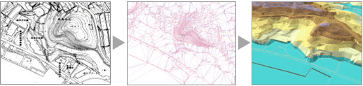
| Import of a paper map | Addition of elevation information | 3D display and checking |
Figure 1. Flow of data creation
 Visualization Gallery
 Acceptable source maps
We ask the client to obtain a paper map of approximately 1:2500 from local government or other sources. The map will serve as the source data.
Maps with other scale ratios such as 1:500 and 1:5000 are also acceptable for the 3D elevation data creation as long as elevations are labeled clearly on the maps.
Acceptable maps
- Printed contour maps, photocopied contour maps (maps with clearly drawn lines)
- Maps with geodetic coordinates at the four corners.
Unacceptable maps
- Diazo maps, colored drawings, maps with creases, and maps with unclear printing
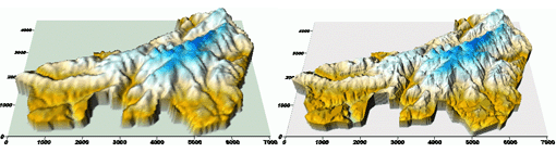
| 50m elevation data of the Geographical Survey Institute of Japan | 5m data created from a paper map |
Figure 2. Comparison of spatial resolutions
Data precision and accuracy
- The precision and accuracy of the 3D elevation data to be created is dependant on the source map.
Time required
- Approximately 1 week per map (general guideline)
Fee for the 3D terrain data creation
- Please contact us for estimates.
- The fee for a typical case is approximately 100,000 yen.
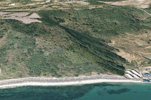 Figure 3. Composite of a 3D topography model and an aerial photo
Intended mainly for sites outside Japan
Detailed 3D topography data creation service for use in RIAM-COMPACT® Natural Terrain Version
Creation of topography from terrain data from the Shuttle Radar Topography Mission (SRTM) and the Earth observation satellite DAICHI (ALOS)
Creation of high-resolution elevation data has been highly limited for wind simulation for sites outside Japan.
With the use of the topography data from the Shuttle Radar Topography Mission (SRTM) or the Earth observation satellite DAICHI (ALOS), we create 3D elevation data (latitude-longitude ASCII elevation data) for use in RIAM-COMOPACT® Natural Terrain Version at a low cost and with a short delivery time. We can also nest ALOS data within SRTM data to create more efficient elevation data.
The created data allow wind simulations of high accuracy for sites outside Japan. In addition, these elevation data can also be created for sites within Japan.
For SRTM data (spatial resolution: approx. 90m)
Area specification for elevation data creation
- The client chooses the central latitude and longitude.
- We create elevation data for an approximately 10km x 10km area.
Time required
- Approximately 1 week for each site (general guideline)
Fee for 3D terrain data creation from SRTM data
- Please contact us for estimates.
- The fee for a standard case is approximately 100,000 yen.
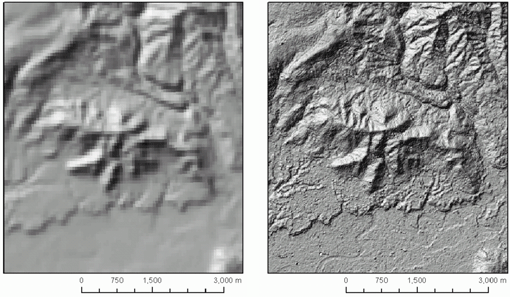
| 90m SRTM data | 10m ALOS data |
Figure 4. Comparison of spatial resolutions
For ALOS data (spatial resolution: approx. 10m)
Area specification for elevation data creation
- We ask our clients to check the image of the site for which elevation data are to be created by contacting the sale agent, RESTEC (http://www.restec.or.jp/).
- In case missing values exist in the ALOS dataset due to sporadically occurring clouds, the elevation data will be missing for the corresponding locations.
- After clients have checked the image, they are asked to specify the central longitude and latitude.
- We create elevation data for an approximately 10km x 10km area.
Time required
- Approximately 3 weeks for each site (general guideline)
- Approximately 2 weeks are required for the delivery of the source data from RESTEC.
Fee for 3D terrain data creation from ALOS data
- Please contact us for estimates.
- Our estimates will include the price of the source data from RESTEC: 315,000 yen (sales tax included).
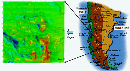 Figure 5. An example of analysis with RIAM-COMPACT® Natural Terrain Version
together with ALOS data.
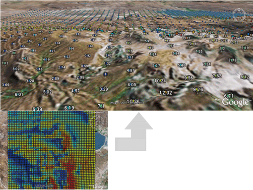 Figure 6. An example of using Google Earth to view the result
MAP file creation service for use in the linear wind simulation software WAsP
We create MAP files (contour data in the UTM coordinate system) for the linear wind simulation model WAsP developed by the RISO National Laboratory of Denmark. The source data of the MAP files are the high-resolution elevation data (DEM data in the latitude-longitude coordinate system) that are created by our corporations. The MAP file can be created with any desired intervals.
This allows comparisons of the outputs by RIAM-COMPACT® Natural Terrain Version (a non-stationary, non-linear CFD model) and those by WAsP (a linear wind simulation model) with the same spatial resolution of elevation data.
The MAP file can be prepared from the Shuttle Radar Topography Mission (SRTM) topography data or the Earth observation satellite DAICHI (ALOS) topography data. In this case, the created MAP file is more versatile and can be applied for sites outside Japan. The service described here is also offered for sites within Japan.
Time required
- Approximately two weeks for each site (general guideline)
Fee for data creation
- Please contact us for estimates.
- The fee for a standard case is approximately 100,000 yen.
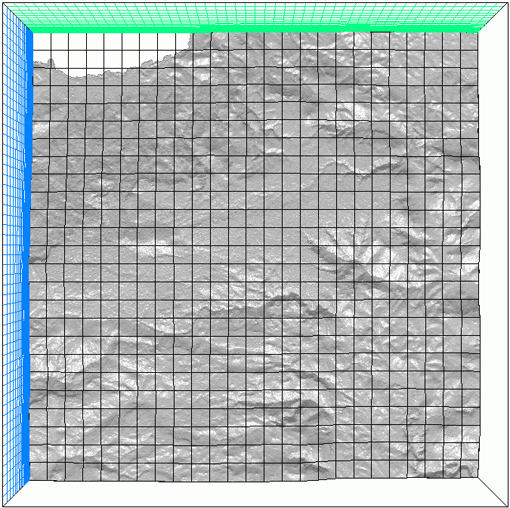 DEM data for use in RIAM-COMPACT® Natural Terrain Version

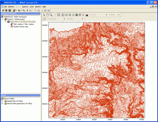 A MAP file for the linear wind simulation model WAsP
Figure 7. An example of data created for a site outside Japan