


Design wind speed estimation service
With the use of the 50m elevation data of the Geographical Survey Institute of Japan, we estimate the design wind speed for the installation location of the wind turbines.
The estimates are based on methods compliant with “Guidelines and descriptions for the structural design of wind power generation facilities and supporting objects: 2007” (Japan Society of Civil Engineers) and “Guidelines and descriptions for architectural loads (2004)” (Architectural Institute of Japan).
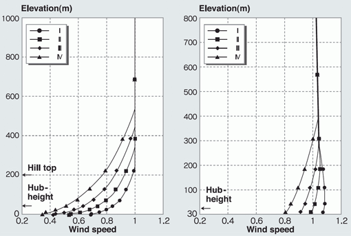
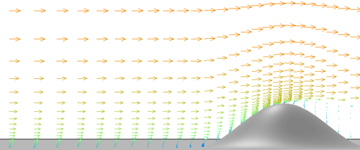
Figure 3. Time-averaged velocity. Roughness classification IV.
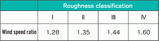
Table 1. Wind speed ratio for a wind turbine hub-height of 45m.
Wind speed ratio = (wind speed at 45m in Figure 2)/(wind speed at 45m in Figure 1)
 Options
- The design wind speed can be estimated from high-resolution wind simulations which utilize elevation data with spatial resolutions of less than 10m.
- Further accuracy of the estimation of the design wind speed can be achieved by combining RIAM-COMPACT® Natural Terrain Version with a meso-scale meteorological model such as the WRF (Weather Research and Forecast) or MM5 (PSU/NCAR Mesoscale Model) models.
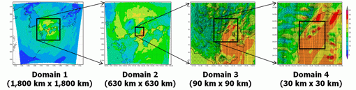
Figure 4. Estimation of design wind speed.
A typhoon simulation was used in these estimations.
The atmospheric layer between the ground surface and 50hPa (20,778m)
is vertically divided into 34 layers.
The grid intervals are 16m and 4,301m for the lowest and highest layers, respectively.
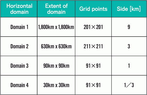
Table 2. Details of domain geometry
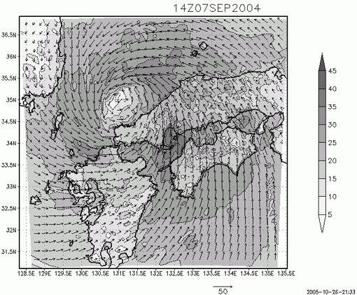
Figure 5. Distribution of horizontal wind velocity at the 10m height
above the ground surface at 1400 on September 7, 2004. Typhoon 0418.
Computational result of MM5 for Domain 2.
Fee for design wind speed estimation service
- Please contact us for estimates